


Freshmap for Mac USB
Regular price $199.95

Freshmap for Mac USB brings you seamless and clear NZ mapping software for MAC USB. Want to draw tracks, routes add waypoints on an easy to use mapping program, yep, me too! The Fresh Maps are made in Christchurch and is a very easy program to navigate to set up your next adventure.
Features for Freshmap for Mac USB
- Topographic mapping at all scales
- Street-level mapping
- Available in NZTM
- Cadastral - property boundaries
- Works with Garmin GPS
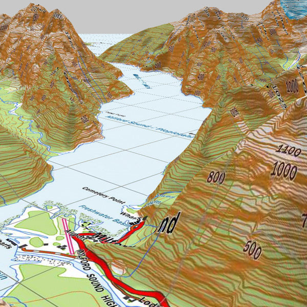
- View maps at 1:50,000 and 1:250,000 Scale in 3D
freshmap topographic
- 1: 20,000 street mapping
- 1: 50,000 detailed topographic with 3D
- 1: 250,000 general topographic with 3D
- 1: 500,000 overview mapping
- 1: 1,000,000 overview mapping
freshmap cadastral
- legal parcel descriptions
- legal roads and public land
- two scales: 1:50,000 and 1:10,000
freshmap Printing
- Printing from Freshmap is easy.
- Print preview allows you to change the scale and the area without having to exit the preview screen to change it.
- Maps can be printed in a variety of scales and sizes.
- Maps can be copied for use in another program, emailed or saved to disk as a file.
freshmap Map Coverage
- Map coverage consists of New Zealand including Stewart Island and the Chatham Islands.
- Includes map scales from 1:1 million to 1:20,000.
- Eight levels of zoom for each map scale
- Sheet numbers provided for the sheet that is being viewed.
freshmap GPS
- Waypoints can be created on the map and uploaded onto your Garmin™ GPS
- The waypoints can also be saved as an XML file for storage
- Sending waypoints to a GPS is as simple as right-clicking with the mouse and choosing Export.
- Tracks can also be drawn on the map and exported to a GPS.
- Support provided for NMEA GPS support
- Real-time tracking
freshmap Search
- This allows the user to search by
- coordinates
- place name
- road name - either rural or urban
- user features - such as a waypoint or track
Garmin™ GPS topo mapping
- 1:50,000 topographic mapping for a colour screen Garmin™ GPS
- Mapping available only on microSD card suitable for the colour screen GPS
GPS Tips, Tricks & Help
Here at Motomox we want to make sure your experience with learning and using a GPS is a good one. For that reason, we've joined forces with Adventure Guide to create a page with tips, tricks, and help with common GPS questions. Click here for our GPS Tips, Tricks and Help page.
Check out all our navigation accessories.